Some images are easier to geolocate than others. If an image is easy to geolocate it is generally because at least one of the following three conditions apply:
- The image context makes it clear. For example there are GPS coordinates embedded in the image, or there is information about the location posted to the internet alongside the image.
- A reverse image search tool like Google Lens or Yandex is able to automatically recognise details in the image that identify the location.
- There are researchable map markers in the image, for example sign posts, business names, prominent landmarks etc.
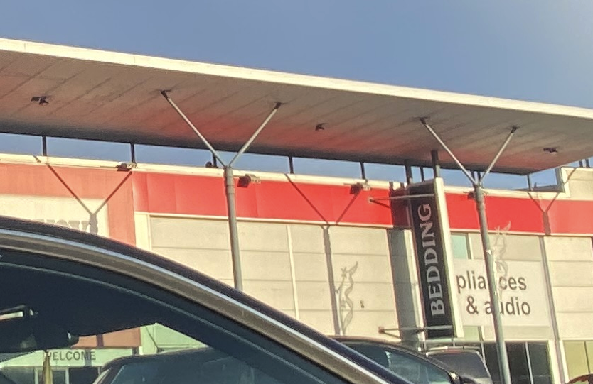
Sometimes none of these conditions apply. When this is the case geolocation becomes much harder and a more methodological structure is needed. Here’s a walkthrough of such an approach to find where the photo below was taken.
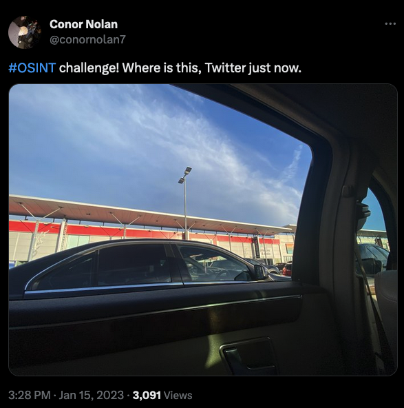
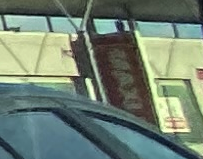
The photo was originally posted by Conor Nolan at 15:28 UTC on Jan 15th 2023. Conor tells us that the image was taken “just now” so at least we know when the image was taken. The problem is we don’t know much else. There’s no helpful GPS data, no luck with a reverse image search, and not much in the way of geographic information that we can easily search for straight away.
We need a more structured methodology to find where Conor took this photo. I have written about gap analysis many times before and will use the same simple investigative structure here. There are four questions to follow to find the answer:
- What do I know?
- What does this mean?
- So what do I need to know?
- How do I find out?
So let’s start at the beginning…
What Do We Know?
There’s little information in Conor’s Twitter profile and his bio says he’s located in London (note: as of 14th April it says Ireland, but it said London at the time this image was posted). There’s certainly not much in the way of immediate accessible information that we can research. It’s often tempting to give up at this point because there doesn’t appear to be any obvious way forward. This is often the case with more challenging images but there are other techniques we can apply to get as much data out of the image as possible. There is always more than you think.
By playing a short game of 20 Questions with the image, we force ourselves to extract as much information as we can about the image and its context. Armed with 20 different data points, we will have lots of new lines of research to follow up until we find the location, and if we still can’t find it we at least know that we have tried everything. We already have a couple of starting points, so let’s find our 20 data points by studying the photo as thoroughly as possible:
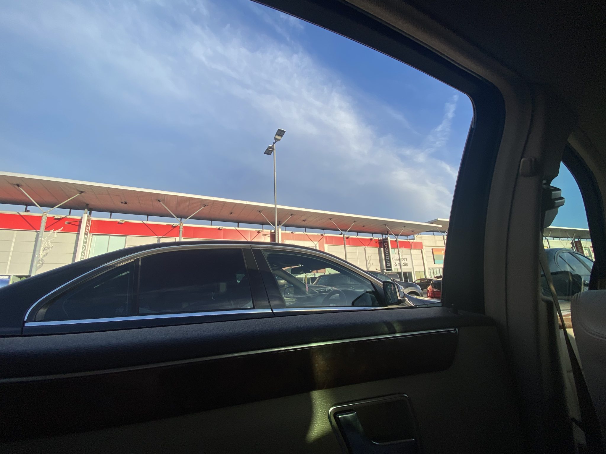
- The image was taken at 15:28 UTC on Jan 15th 2023.
- Conor (the photographer) has London in his Twitter location bio.
- It was daylight when the image was taken.
- The black car in the foreground is right hand drive.
- Conor is in a car park.
- The buildings resemble a retail park.
- Shop #1 has a red hoarding.
- Shop #1 sells furniture, bedding, appliances and audio.
- The name of shop #2 is not visible, but it has a red, orange, green and blue hoarding.
- Shop #3 is hard to see, but we can see a yellow hoarding.
- Shop #4 is called “Maxi” something and has a red and white sign.
- Some Christmas decorations are still visible.
- Shop #5 appears to have a red and white sign.
- The retail buildings are made of long rectangular blocks (metal or concrete?)
- The roof is not flat, it has a two-tier structure (this might help when it comes to aerial imagery later…)
- The roof is supported by external posts.
- Shadows from the support posts are cast onto the front of the building. This will help with orientation.
- The weather conditions are bright with some cloud. No evidence of rain.
- There’s a blue advert/sign with white text on the far left of the image.
Some of these details are more important than others, but we won’t necessarily know exactly which ones until the end. Some details like the shop names are more likely to lead the location than the other details, but the small details will help with the fine tuning and verification at the end.
What Does This Mean?
Time to move to the next phase of gap analysis. We’ve established what we know (and it’s probably a lot more than we first thought) so next we have to figure out what all these data points tell us. It might not look like it yet, but we’ve already got enough data to get us to the objective quite quickly. Here’s what our findings tell us:
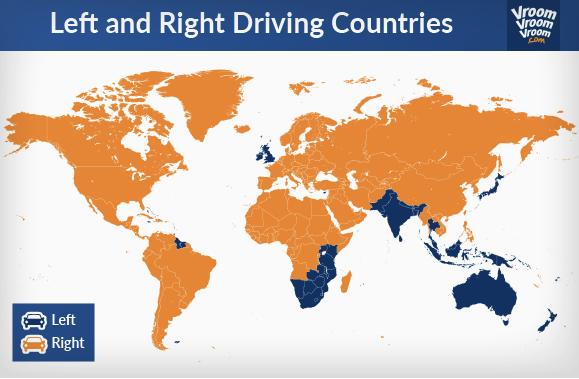
- The right hand drive car means this is a left-hand drive country. Given that it was daylight at the location at 15:28 UTC on Jan 15th 2023 this means that the UK or Ireland is the correct place (the time and daylight means it can’t be Australia etc). Conor’s bio said London – but that doesn’t mean he took the picture there.
- The correct location will be a retail park with a car park in front of it. There will be a shop whose name ends in u, x or y. If English is the language then y is more likely at the end of the name than u or x. The shop sells furniture, bedding and electrical and audio equipment.
- There’s a second shop that might be easier to identify. It’s called “Maxi” – something and has a red and white sign style.
- The store fronts are facing roughly west. Conor is facing east. We can tell this because the shadows indicate the late afternoon sun is coming from over Conor’s shoulder, so west is behind him. This also means the long row of shops will be orientated roughly along a north-south line.
- When we find the approximate location, we should be able to verify that all the other details (roof style, posts, shop signs etc) are present.
All our research so far means that if we can find a retail park in the UK or Ireland that has a “Maxi-?” store (Shop #4) alongside a furniture/bedding/electrical store that matches shop #1 and faces roughly west, we will find the correct location. If there is more than one matching location we can use the smaller details (posts, roof design, building materials etc) to eliminate the incorrect possibilities.
What Do We Need To Know?
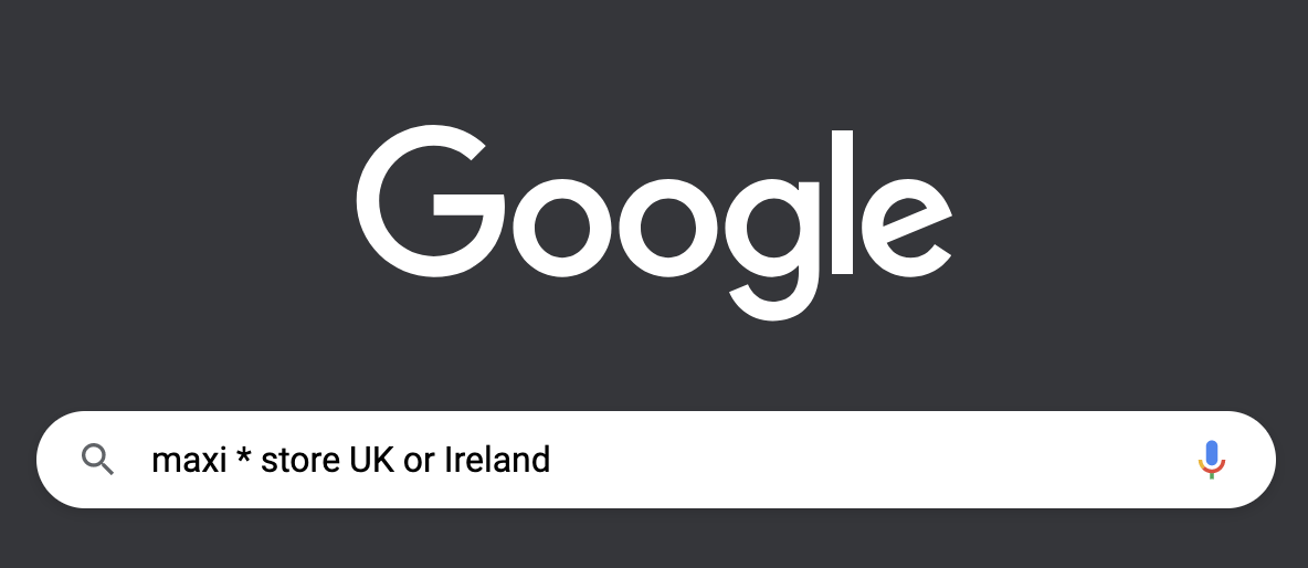
To find the answer we need to choose our strongest line of enquiry. In this case we could either search for stores in the UK and Ireland that sell furniture/electrical goods and end in y, or we could choose to research stores called “Maxi”. You could really choose either as they are both likely to lead to a specific store. I decided to start with the “Maxi” store since it’s clearer what the name is than the large furniture store.
This means that we need to know what the Maxi stores are (with matching name and logo) and where all their retail park stores are in the UK and Ireland. Then when we have found all these, we can eliminate all the retail parks where the shop layout, building, and orientation details do not match.
How Do We Find Out?
Let’s begin by searching for stores that are called “Maxi” in the UK. A Google search with a wildcard for the store name will help (since we don’t yet know if Maxi is a full or partial store name).
There are a few unhelpful results but the first result that mentions a Maxi- retailer is this one which relates to the Maxi Zoo chain of pet stores. The website tells us that Maxi Zoo has 29 stores in Ireland. A Google Image search for Maxi Zoo stores leads to this Shutterstock collection of Maxi Zoo storefronts. By comparing the images to the photo it looks like we’re on the right track.
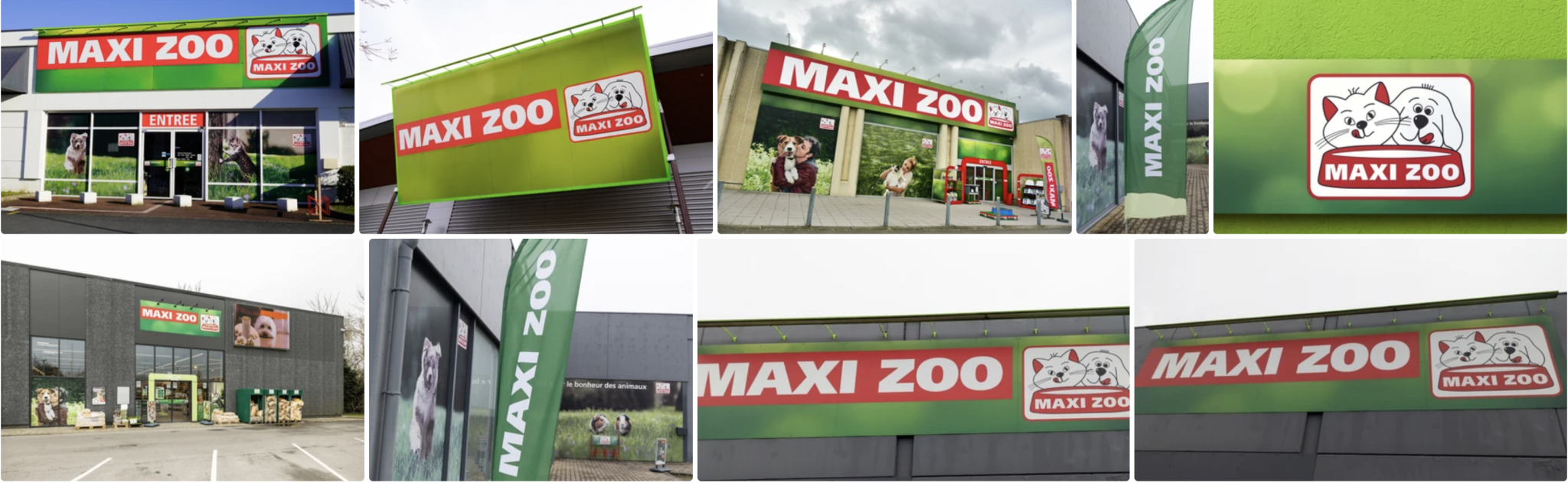
It seems like a good potential match. We’ve already established that the image is most likely in the UK or Ireland on the basis of the right-hand drive vehicle. A little extra research into Maxi Zoo shows that it has stores in Ireland, but none in the UK. This will prove to be helpful since it will mean we only have to focus on Ireland rather than the UK to find the correct location.
Finding The Right Store
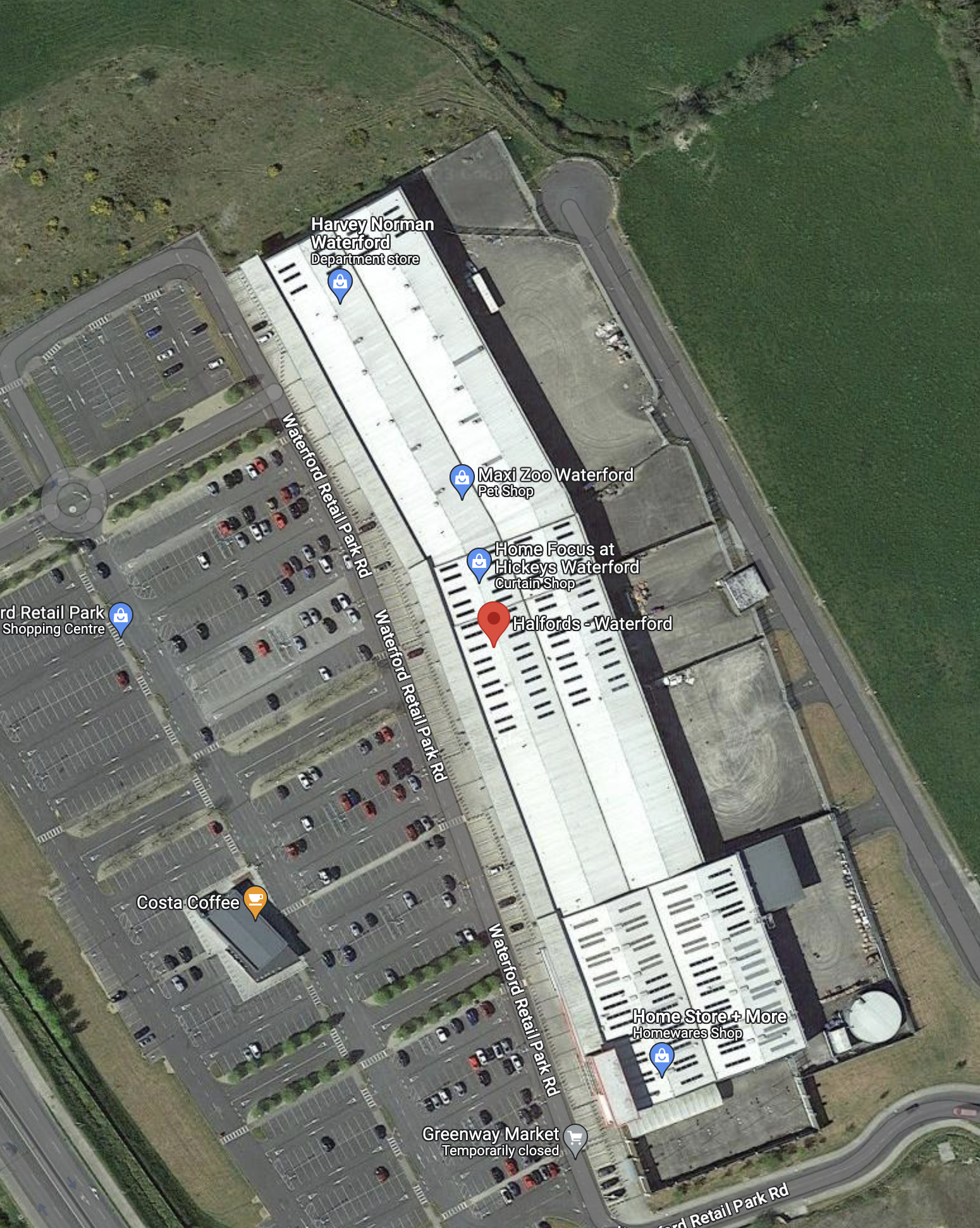
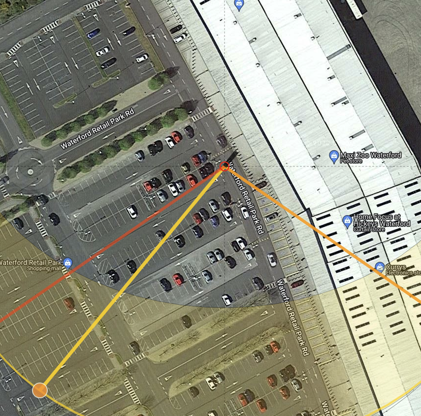
Based on what we’ve found so far, we need to focus on trying to identify which one of the 29 Maxi Zoo stores in Ireland Conor was next to when he took the picture. As we look at each location we can quickly check if any of the other shops or architectural features we pulled from the original image are present. If they aren’t the location can be discounted.
Google Maps makes this process quite straightforward. By focusing the map on Ireland and ticking the “Update results when map moves” option the stores are highlighted as the map moves around.
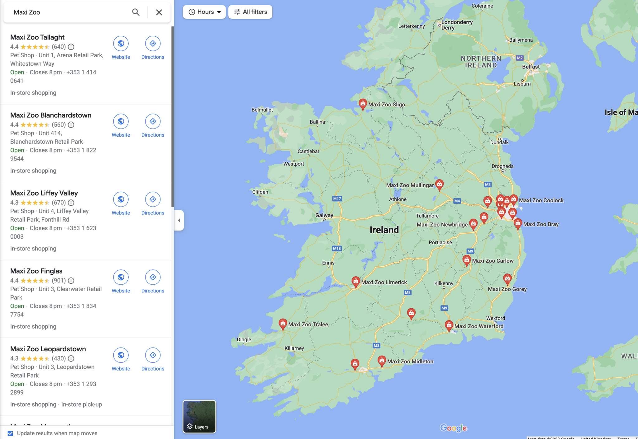
Clicking on the link on the left hand side of the map brings up a picture of the store so each one can be quickly ruled in or out. 29 stores sounds like a lot to get through but with this method it only takes a few minutes.
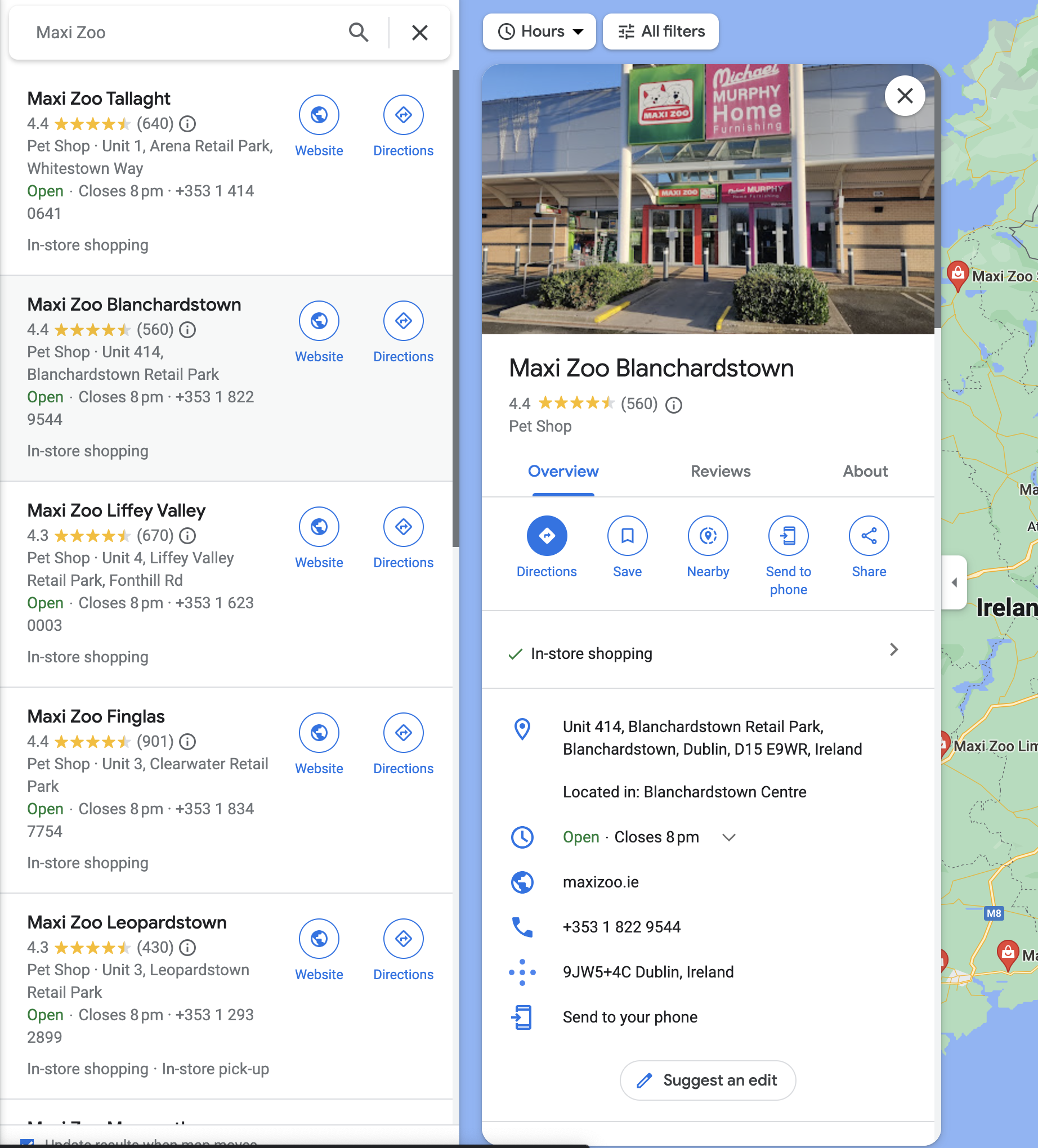
In this case we can see straight away that the Maxi Zoo in Blanchardstown is not the one in the original picture. The storefront architecture doesn’t match.
After a few more false starts, the Maxi Zoo in Waterford looks a little more promising.
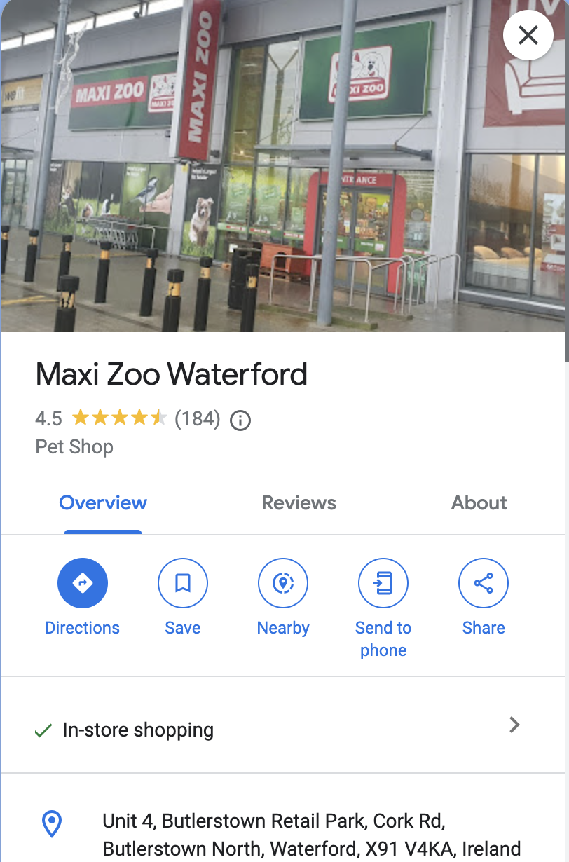
Notice the store sign hangs vertically down like in the original photograph. The shop next door (shop #3) has a yellow sign and on first glance the architecture seems to match. It might not be right, but it definitely can’t be ruled out. We need to take a closer look.
The best way to do this is with Google Street View. There’s no direct coverage of the car park itself but the coverage from the road outside is good enough to make an assessment:
This is where the time spent focusing on tiny details at the start pays off. If we’re right about the location, we should be able to see all of them present in the image above. Let’s check:
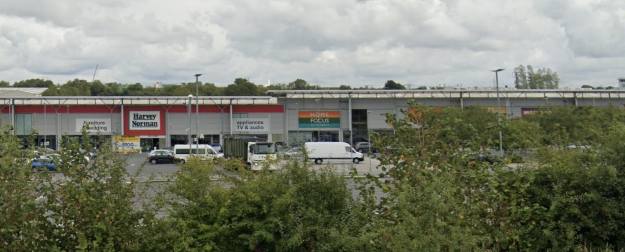
- Harvey Norman – the signs, logo and font match the original image. This is the bedding, appliances and audio store (shop #1).
- Next door is a shop with the rainbow coloured hoarding. It’s in the same place as in the original image. We can see that shop #2 is a Home Focus At Hickeys. Compare this image to Conor’s original:
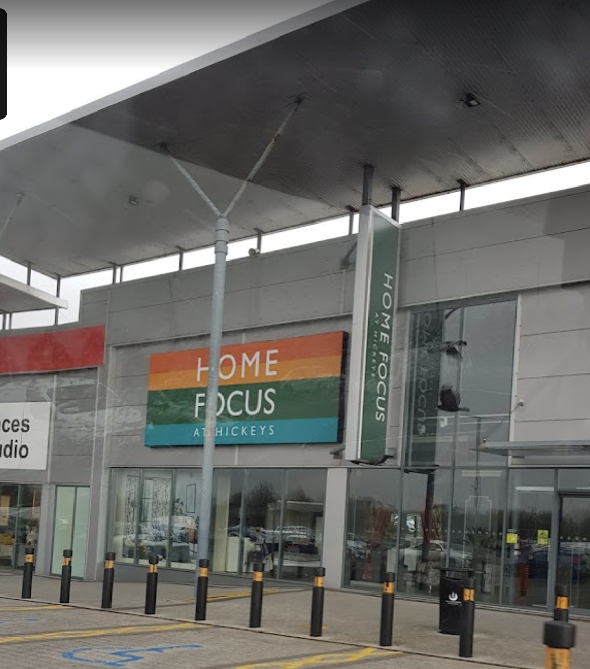
3. Next door to Home Focus we can see that the shop with the yellow sign is a Halfords (Shop #3).
4. The two tier roof between Harvey Norman and Home Focus is in the same place as in the original image. The metal block panels and external roof support architecture all match as well.
5. The only piece of information we are given at the start is that the image was taken at 15:28 UTC on 15th Jan 2023. The shadows in the original image suggested that the building should be aligned roughly North-South, with Conor looking east. The orientation looks good:
To verify this is correct, we can use Suncalc to see if the shadows at the location match up with what Conor’s photo shows. Suncalc says that the shadows should be orientated like this:
This matches perfectly with the shadows in the original image – perfect!
So we can see that our structured methodology has served us well and made geolocating this image possible even with somewhat limited initial information. There is always more information in an image than first appears and we can use every last piece of it to find what we are looking for.
If you enjoyed this post check out my other geolocation posts here.
Excellent walk-thru! Thank you.
Wonderful walkthrough. Very well explained.
Pingback: Geolocation: At The Retail Park - Whalers Blog