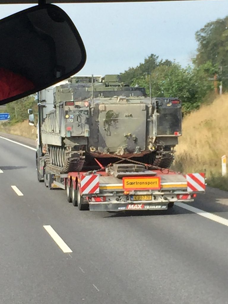
This Sunday we were treated to an extra Quiztime image location challenge which involved an unidentified military vehicle. Doxsor posted this image and asked where this military vehicle was headed to, and which barracks was closest to the location:
This was a good opportunity to practise military vehicle identification and explore how military units are organised and structured. OSINT is a very wide and varied discipline, but if your work focuses on conflict zones like Libya, Syria, or Ukraine, then being able to identify military vehicles and those that use them can be an integral part of an investigation. Bellingcat’s recent work on MH17 is a prime example of how essential this skill can be.
The rest of this post will look at how I identified the vehicle and unit, before finding the correct location.
Tanks & Armoured Fighting Vehicles
There were a few ways to start of this puzzle, but I began with the number plate on the trailer. 6 digits in black print on a yellow background could be several different countries, but two strong candidates were the Netherlands and also Denmark. (World Licence Plates is a great resource for this kind of thing). So I thought if I could find images of vehicles used by the Dutch and Danish armies, it would be possible to confirm the vehicle type and then work from there to identify the units that used this vehicle, before finally identifying where these units were based.
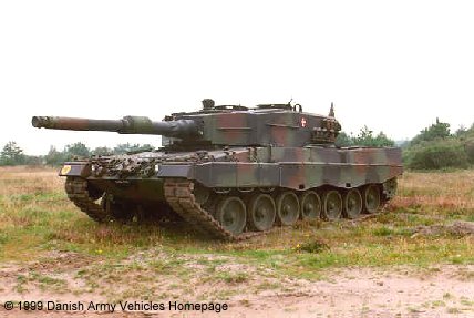
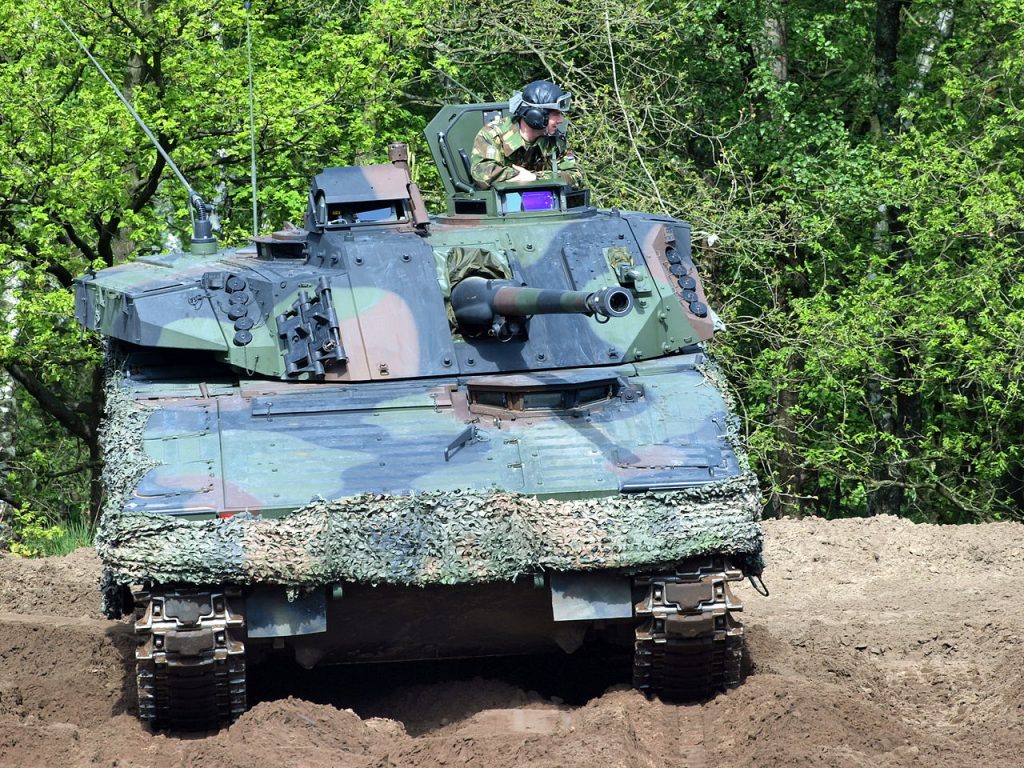
But how to identify the vehicle? To most people it looks like a tank – but this is not strictly correct. Even if you’re not a military buff, there are a few features in this photo that help to identify the general vehicle type. The vehicle has tracks and a turret on top – but it is not a tank. Tanks are generally much larger, have bigger guns, are more heavily armoured, and do not have the ability to transport additional soldiers internally.
The vehicle in the quiz image has a door at the rear like the one below, which indicates that it is designed to accommodate additional soldiers. This means that the vehicle is not a tank, but a kind of armoured personnel carrier, also known as an armoured fighting vehicle. This is important because it means the unit that uses this vehicle will most likely be a reconnaissance / mechanised / armoured infantry unit, and not a tank or cavalry unit.
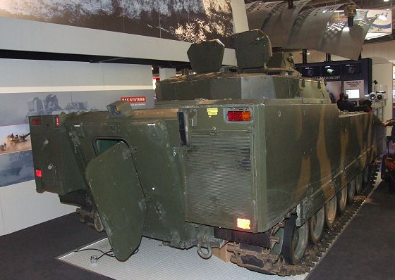
So first of all I looked at what kind of tracked vehicles the Dutch army uses. The only vehicle they use that fits the criteria (tracks, turret, rear door) is this CV90:
So next I looked at the vehicles used by the Danish army, and again the only possible match was also the CV90:
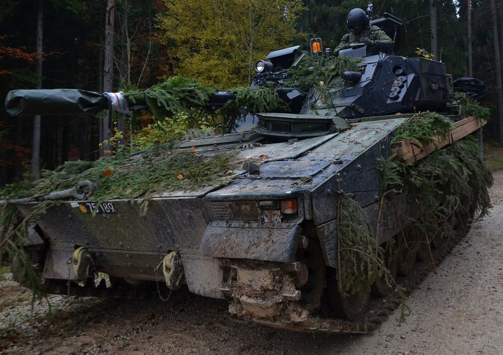
It turns out that the CV90 is used by lots of different countries. So how to determine who the CV90 in the original picture belonged to? I noticed that the registration plate on the Danish CV90 pictured above was identical in style to the one in the Quiztime image. The yellow circle emblem followed by the five digit serial was very similar:
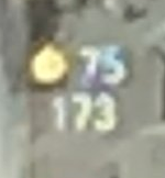
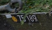
The identical symbol and similar number sequence (75 1xx) made me fairly sure this CV90 belonged to the Danish army and not to any other country.
Unit and Barracks
So if the CV90 was Danish, was it possible find out where it was based and where it might have been headed to when the picture was taken? Fortunately the Danish Army is very small, and its main combat units are based at only two different locations. There are some additional bases for support units, but a vehicle like the CV90 belongs to a front line combat unit. This Wikipedia page gives some insight into how the army is structured, and this unofficial Danish Army site states that the CV90 was only issued to two units, the Life Guards and the Guards Hussar Regiment.
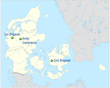
Taking all these things into account, it seems that there were only two possible locations, either 1st Brigade at Holstebro, or 2nd Brigade at Slagelse. While there are a few other army bases around Denmark, only these two garrisons seem to house combat units of the sort that use the CV90. Helpfully Wikipedia also provides a structural overview of the Danish Army that made things a little clearer:
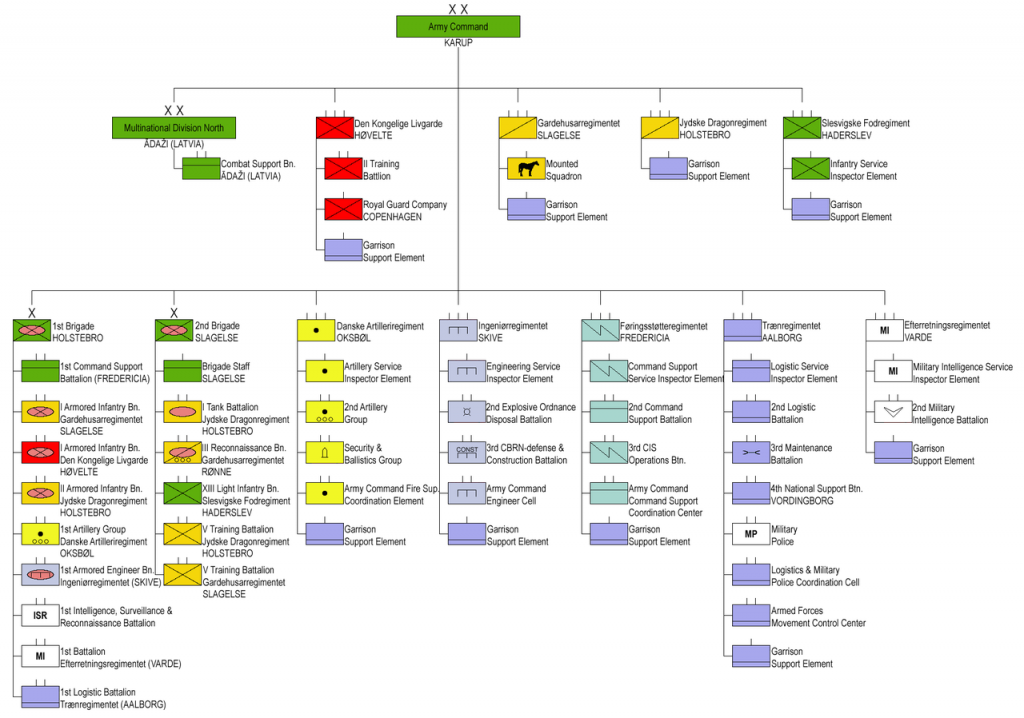
Somewhat unhelpfully this shows that the units equipped with the CV90 (Life Guards and Guards Hussars Regiment) are split between Slagelse and Holstebro, which didn’t actually help at all with the location challenge since they are a long way apart and could have been based at either location. Was there any clue that could help point in the right direction? There was one additional detail on the back of the CV90 that indicated a possible link to Slagelse. This symbol from the back of the CV90 bore a strong resemblance to the official badge of the 2nd Brigade, based at Slagelse:
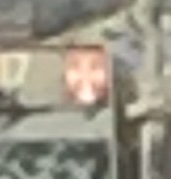
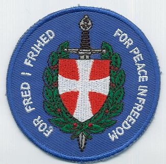
Based on this I thought Slagelse was a more likely location for the vehicle’s home base rather than Holstebro. Having said all that, military vehicles move frequently, and units can be deployed almost anywhere at any time, so it is important to keep an open mind about possible locations.
Finding the CV90
So I was confident about the type of vehicle it was, and which unit it probably belonged to. I knew it was Danish, but that didn’t actually help locate the vehicle. Apart from anything else, the vehicle was moving and could be anywhere. Doxsor said it was near to a military barracks – but the two most likely candidates (Slagelse and Holstebro) were at opposite ends of the country, so where to start?
First of all I decided to focus on the road sign that was just visible on the left of the original image. This was a mistake, but I didn’t know that at the time.
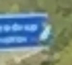
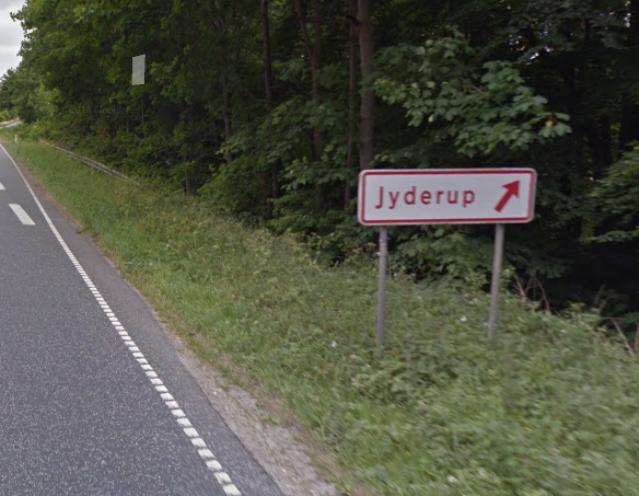
The text isn’t too clear, but I though the top line said something –derup. My knowledge of Denmark’s geography is not good, so I did a Google search for *derup + Denmark in order to try and find the place name. The clearest match was for the town of Jyderup, which is not all that far from Slagelse (about 35 minutes’ drive). The only main road near Jyderup is highway 23, but no matter where I looked, I couldn’t find any locations that looked right. The 23 is mostly a single-track road, but the road in the picture looked like a multi-lane motorway. The signs were also very different. This is the sign for the exit from the 23 heading towards Jyderup:
The sign was red text on a white background, but the kind of sign I was looking for was a standard motorway sign with white text on a blue background like this one:
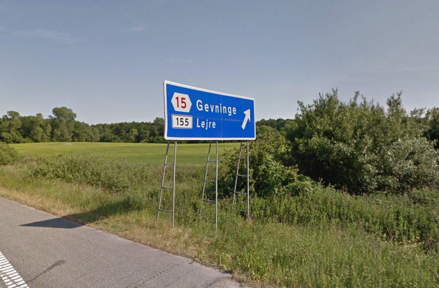
This meant that the 23 was definitely not a motorway, only a large trunk road. More importantly this meant that not only could Jyderup not be the correct location, but the real location must be on a motorway. Up until this point I had tried to do this quiz on my laptop with a 15″ screen. As soon as I switched to my PC with a much larger monitor it became clear I had been mistaken and that the sign in the quiz image could not possibly say “Jyderup”. Apart from anything else there was clearly another letter before the d in drup/derup and it wasn’t a y.
So Jyderup was not the right place, but through this diversion I learned that in order to find the location it would only be necessary to focus on motorways and not any other roads, since the blue signs with white text seemed to be exclusive to motorways.
What Does The Picture Actually Show?
After the Jyderup diversion I went back to the original image to see what other information it held. I’ve posted before about asking questions of an image, and it can be very helpful to help articulate precisely what you can see in front of you. I had already got a lot of detail about the CV90, but was there anything in the image that could be used to find the location? Actually there was quite a bit once I looked at it again:
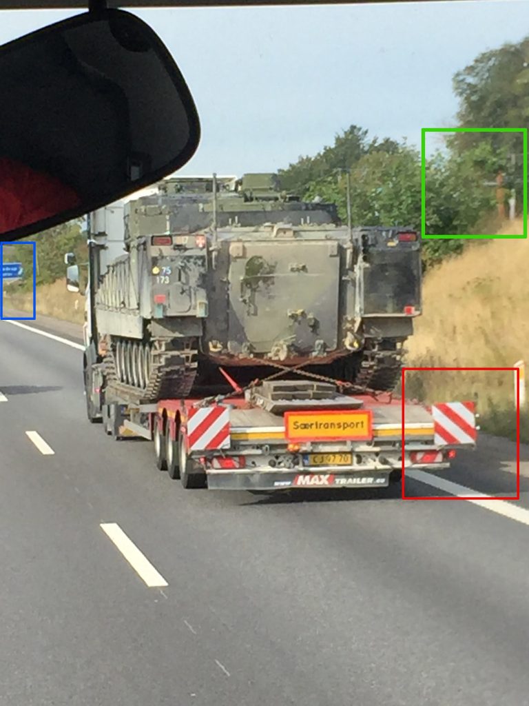
1) Red Box – this is the shadow of the vehicle – so what does it show? Looking at the trees, the image must have been taken in summer. Denmark is in the northern hemisphere, so the sun is always to the south (i.e. it never shines from the north). So the fact that the vehicle’s shadow is on the right of the picture must mean that the sun is to the left. This means that the vehicle must be heading roughly west, and the orientation of the motorway must be roughly West-East, it is unlikely to be North-South. In theory it could be dawn or dusk with the sun shining from the East/West, but the relatively short shadow length made me think this was less likely.
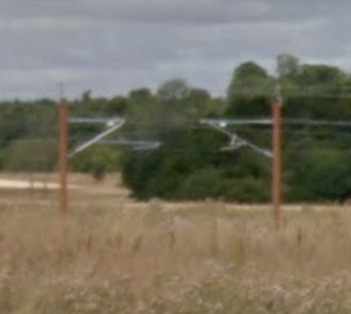
2) Green box – this shows the top of an electrical mast like the type used by electric trains. It appears to be a railway running parallel to the motorway. I found a full picture of an electrical railway set up to confirm the type used in Denmark:
3) Blue box – The sign shows an exit for a place ending with -drup, and a second place ending with -ov, or -on. There also appears to be something else behind the sign that is grey, perhaps road or a bridge.
So putting everything together, it was already possible to be sure of the following:
1) The location is on a motorway that most likely runs West-East / East-West
2) The motorway is parallel to an electric railway (thanks to @JTillerup for pointing this out)
3) The railway must be on the northern side of the motorway, not the southern side.
4) The location is next to a motorway exit for a place ending in -drup / -derup and another place ending in -ov/-on.
5) It must be quite close to one of the military barracks at either Holstebro or Slagelse.
So by strictly applying these criteria, it is possible to narrow down the search area very quickly. Look at the map of Denmark below, which shows all the main motorways:
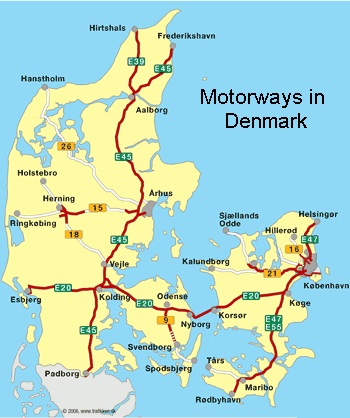
It might seem like a huge search area, but by applying the five criteria above it is possible to find the right part of Denmark quite quickly. The E39, E45, E47 and E55 can be immediately discounted because they run North-South and not West-East. This really just leaves the E20, which runs West-East across Denmark. The E20 is also nowhere near Holstebro, which means Slagelse is the most likely of the two barrack locations. For this reason I also decided not to focus on the western section of the E20 between Esbjerg and Kolding because it was a long way from either of the military bases. I decided to work from Copenhagen towards Odense first. The aim would be to see which section of the motorway had an electric railway running parallel to it on the northern side and then focus on that.
The advantage of this approach is that it was possible to work with Google Maps in satellite mode from quite a high altitude. At this stage I was only looking for a railway next to a motorway, so there was no need for street-level detail. You could drive along the E20 in streetview mode of course, but it would take a long time. Working from this kind of height also means it is possible to cover a large area in a very short time:
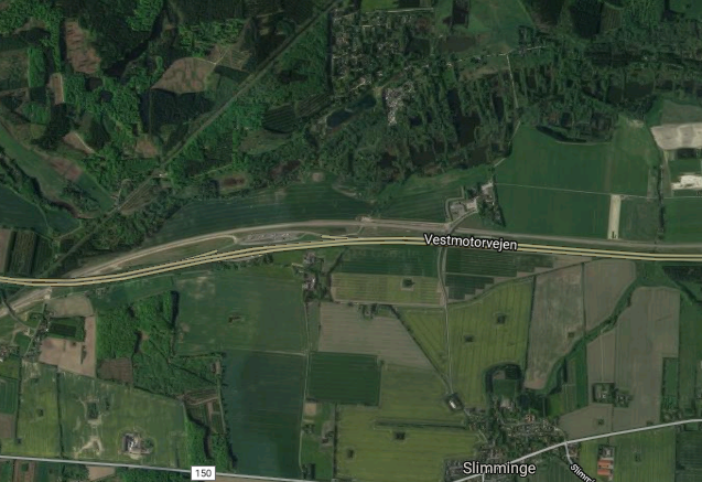
After about ten minutes of checking, the only part of the E20 that had a railway alongside AND ran from West-East was the section between Olby and Fjaellebro, (there is another tiny section near Svenstrup, but a quick check with Streetview showed it didn’t match). The Olby-Fjaellebro section is only approximately 20 kilometres of road so it was only quite a small area to focus on.
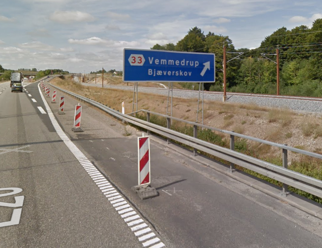
The target location had to be near to an exit junction, of which there are only 4-5 in this section. Secondly, the exit had to be for a place name that ended with -drup and a second place ending with -or/-ov. A very quick street view check focusing only on the points of exit led me here, Exit 33 for Vemmedrup and Bjaerskov.
By applying the criteria that the correct location must possess, this was the only possible location where Doxsor could have taken the picture, but there was only one problem – it does not look anything like the photograph! In the original photo there is an embankment and some bushes next to the motorway, but here there was no embankment and no bushes.
Right Place, Wrong Perspective
I was slightly puzzled at this point, and I think Sector035 had reached a similar stumbling block. Surely there was some contradiction? Logically this must be the correct place, but the Street View image did not match. I like to think that there is no such thing as a contradiction, and that if you think you have found one, then it means that one of your initial assumptions must be wrong. This turned out to be the case, although I was not very far off (only by a few metres in the end).
After rechecking how I got to the location, I tried to play around with Street View a little bit to try and recreate the original photo, because I was still sure that logically this must be correct.
In the original picture Doxsor was much further away from the road sign, so I backed up a little bit with Streetview and came to this position:
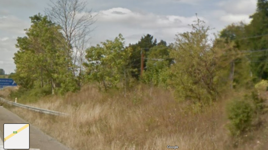
It looks almost right, but not quite. The sign also seems correct when you compare Street View to the original:
But in the original there is also no crash barrier. However after a few minutes of trying to replicate the original image as much as possible, I noticed that the Google Street View car was in Lane 1 of the motorway (inside lane), but Doxsor must have taken his photo from Lane 2 (outside lane), so this explained the slight differences of angle between Street View and the original picture. This along with the position of the truck in the original image also explains why the crash barrier is not quite visible.
So the correct location was exist 33 of the E20 near Vemmedrup, and the nearest military barracks that the CV90 could have been heading to was most likely Antvorskov Barracks at Slagelse.
For more Quiztime-related posts click here.
I love to read your summaries. Fascinating literature – and I am always learning something new.
I love to read your summaries. Fascinating literature – and I am always learning something new.
Pingback: An OSINT guide for military research – Center for Undersøgende Journalistik
I do not even understand how I stopped up right here, but I thought this
put up was once great. I don’t realize who you might be however definitely you’re going to a
famous blogger if you happen to aren’t already. Cheers!